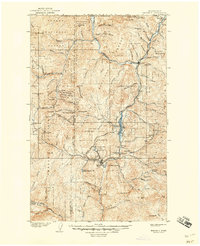
1904 Map of Republic
USGS Topo · Published 1944About this map
Republic sits at the heart of this gold-mining region in the early twentieth century, serving as a hub for the hard-rock operations that dot the surrounding peaks. The map reveals an industrial landscape defined by high-altitude extraction, with the Mountain Lion Mine and Tom Thumb Mine located just north of the settlement. The arrival of the Great Northern Railway and the Spokane and British Columbia Railway transformed the isolation of the Curlew Valley, providing the essential infrastructure to move ore from the northern borderlands down toward southern processors.
Find a feature on this map
91 named features on this map. Tap any name to fly to it.
Don’t see what you’re looking for? This feature index may not catch every label — zoom into the map to look around manually.
Map Details
Editions of this 1904 Republic Map
4 editions found
Other maps of this area

1902 · Osoyoos
USGS Topo · 1:125,000

1904 · Osoyoos
USGS Topo · 1:125,000

1904 · Republic
USGS Topo · 1:125,000

1936 · Marcus
USGS Topo · 1:96,000

1942 · Marcus
USGS Topo · 1:125,000

1948 · Curlew
USGS Topo · 1:62,500

1948 · Republic
USGS Topo · 1:62,500

1948 · Sherman Peak
USGS Topo · 1:62,500

1948 · Togo Mountain
USGS Topo · 1:62,500

1951 · Wauconda
USGS Topo · 1:62,500