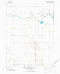
1973 Map of Reservoir Lake
USGS Topo · Published 1977About this map
Champion stands as a focal point in this Chase County landscape, where the waters of Frenchman Creek are managed through a series of mid-century irrigation and recreational features. The map illustrates a complex water management system including the Kilpatrick Dam, a Flume, and a Siphon that directs flow into Reservoir Lake. This hydraulic infrastructure supported both local agriculture and the development of the Champion State Recreation Area at the Mill Pond.
Find a feature on this map
18 named features on this map. Tap any name to fly to it.
Don’t see what you’re looking for? This feature index may not catch every label — zoom into the map to look around manually.
Map Details
Editions of this 1973 Reservoir Lake Map
This is the sole edition of this map. No revisions or reprints were ever made.
Other maps of this area

1954 · McCook
USGS Topo · 1:250,000

1957 · McCook
USGS Topo · 1:250,000

1958 · McCook
USGS Topo · 1:250,000

1961 · Lamar
USGS Topo · 1:24,000

1973 · Champion
USGS Topo · 1:24,000
1973 · Lamar
USGS Topo · 1:24,000
1973 · Chase
USGS Topo · 1:24,000

1973 · Champion SW
USGS Topo · 1:24,000

1973 · Imperial
USGS Topo · 1:24,000

1973 · Reservoir Lake SE
USGS Topo · 1:24,000