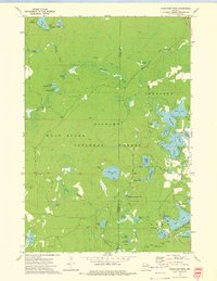
1972 Map of Reservoir Pond
USGS Topo · Published 1975About this map
Nicolet National Forest dominates this northern Wisconsin landscape, characterized by a complex network of glacial kettle lakes and springs. Centered on the boundary between Wolf River and Townsend, the area is defined by the expansive Reservoir Pond and a dense collection of smaller waters including Mary Lake and Explosion Lake. The terrain is marked by significant hydrological features like the Jones Spring Impoundment and named springs such as Mc Caslin Spring and Barney Spring, which feed into the South Branch Oconto River. Evidence of former industrial activity is visible in the long Railroad Grade that cuts across the northern section, while recreational development is anchored by the Ada Lake Lookout Tower and organized sites like the Boot Lake Campground. The presence of several gravel pits suggests local resource extraction amidst the heavily forested hills and wetlands.
Find a feature on this map
52 named features on this map. Tap any name to fly to it.
Don’t see what you’re looking for? This feature index may not catch every label — zoom into the map to look around manually.
Map Details
Editions of this 1972 Reservoir Pond Map
2 editions found
Other maps of this area

1942 · Wabeno
USGS Topo · 1:48,000

1942 · Pearson
USGS Topo · 1:48,000

1950 · Wabeno
USGS Topo · 1:48,000

1950 · Lily
USGS Topo · 1:48,000

1951 · Wabeno
USGS Topo · 1:48,000

1952 · White Lake
USGS Topo · 1:48,000

1952 · Langlade
USGS Topo · 1:48,000

1954 · Iron Mountain
USGS Topo · 1:250,000

1959 · Iron Mountain
USGS Topo · 1:250,000
1972 · Wabeno
USGS Topo · 1:24,000