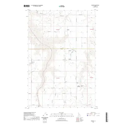
2020 Map of Reubens
USGS Topo · Published 2020About this map
Reubens serves as a central hub on this Nez Perce and Lewis County borderland, where the terrain transitions between high agricultural plateaus and deep drainage systems. The landscape is defined by the significant incisions of Big Canyon Cr and Lapwai Cr, which dictate the local road network and historic settlement patterns. Smaller communities like Chesley and Kippen occupy the flatter sections of the T35N R2W township, while Craig Junction marks a key intersection further south. Local genealogy is anchored by sites such as Coldsprings Cem and Gold Ridge Cem near the western edge. Notable geographical features like Pickle Canyon and Coldspring Canyon illustrate the complex topography that early settlers navigated to establish these remote homesteads and crossroads.
Find a feature on this map
54 named features on this map. Tap any name to fly to it.
Don’t see what you’re looking for? This feature index may not catch every label — zoom into the map to look around manually.
Map Details
Editions of this 2020 Reubens Map
This is the sole edition of this map. No revisions or reprints were ever made.
Other maps of this area

1924 · Kamiah
USGS Topo · 1:125,000

1955 · Pullman
USGS Topo · 1:250,000

1958 · Pullman
USGS Topo · 1:250,000

1958 · Culdesac
USGS Topo · 1:62,500

1967 · Fletcher
USGS Topo · 1:24,000

1967 · Craigmont
USGS Topo · 1:24,000

1967 · Peck
USGS Topo · 1:24,000
1967 · Winchester East
USGS Topo · 1:24,000
1968 · Winchester West
USGS Topo · 1:24,000

1981 · Orofino
USGS Topo · 1:100,000