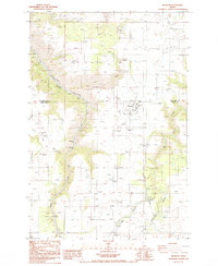
1984 Map of Reubens
USGS Topo · Published 1984About this map
The agricultural plateau of Camas Prairie dominates this 1980s landscape, centered on the small rail-aligned settlement of Reubens. Located at the boundary of Nez Perce Co and Lewis Co, the map documents a region where high-altitude farming and deep canyon drainage meet. While Reubens serves as a local hub with its Storage Bins and cemetery, smaller named locations like Kippen, Clicks, and Nucrag reflect the scattered nature of community and transport along the prairie.
Find a feature on this map
21 named features on this map. Tap any name to fly to it.
Don’t see what you’re looking for? This feature index may not catch every label — zoom into the map to look around manually.
Map Details
Editions of this 1984 Reubens Map
This is the sole edition of this map. No revisions or reprints were ever made.
Other maps of this area

1924 · Kamiah
USGS Topo · 1:125,000

1955 · Pullman
USGS Topo · 1:250,000

1958 · Pullman
USGS Topo · 1:250,000

1958 · Culdesac
USGS Topo · 1:62,500

1967 · Fletcher
USGS Topo · 1:24,000

1967 · Craigmont
USGS Topo · 1:24,000

1967 · Peck
USGS Topo · 1:24,000
1967 · Winchester East
USGS Topo · 1:24,000
1968 · Winchester West
USGS Topo · 1:24,000

1981 · Orofino
USGS Topo · 1:100,000