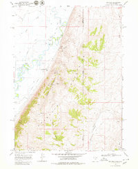
1968 Map of Rex Peak
USGS Topo · Published 1980About this map
Crawford Mountains dominate the central landscape of this late-1960s survey, straddling the high-country boundary between Rich County, Utah, and Lincoln County, Wyoming. The terrain is marked by a complex network of canyons and hollows, including Brazier Canyon and Coal Hollow, which give way to the winding course of the Bear River in the west. This river valley supports a concentrated infrastructure of water management and ranching, evidenced by the Beckwith Canal, Quinn Canal, and Larson Dam.
Find a feature on this map
31 named features on this map. Tap any name to fly to it.
Don’t see what you’re looking for? This feature index may not catch every label — zoom into the map to look around manually.
Map Details
Editions of this 1968 Rex Peak Map
2 editions found
Other maps of this area

1912 · Randolph
USGS Topo · 1:125,000

1954 · Sage
USGS Topo · 1:62,500

1954 · Ogden
USGS Topo · 1:250,000

1958 · Ogden
USGS Topo · 1:250,000

1960 · Ogden
USGS Topo · 1:250,000

1962 · Sawtooth Mountain
USGS Topo · 1:24,000

1962 · Windy Point
USGS Topo · 1:24,000

1968 · Rex Peak
USGS Topo · 1:24,000

1968 · Randolph
USGS Topo · 1:24,000

1968 · Woodruff
USGS Topo · 1:24,000