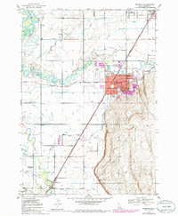
1949 Map of Rexburg
USGS Topo · Published 1986About this map
Rexburg sits at the heart of this post-war landscape, serving as a regional center for education and agriculture. The prominence of Ricks College and the Courthouse underscores its status, while the surrounding terrain is defined by an intricate network of irrigation, including the Ward Canal, Island Canal, and Rexburg Canal. These waterways draw from the Henrys Fork and Teton River, fueling a rural economy dotted with small settlements like Sugar City, Salem, and Thornton. The mapping captures a specific moment of infrastructure, showing the Union Pacific rail lines and the dual routes of the Pacific Highway and Yellowstone Highway before modern interstate development. Local life is documented through features like the Rigby Hosp, Adams Sch, and the Independence Ward Ch, providing a detailed view of the community's social and spiritual foundations.
Find a feature on this map
39 named features on this map. Tap any name to fly to it.
Don’t see what you’re looking for? This feature index may not catch every label — zoom into the map to look around manually.
Map Details
Editions of this 1949 Rexburg Map
4 editions found
Other maps of this area

1948 · Rigby
USGS Topo · 1:24,000

1948 · Parker
USGS Topo · 1:24,000

1949 · Rexburg
USGS Topo · 1:24,000

1949 · Rigby
USGS Topo · 1:24,000

1950 · Ririe
USGS Topo · 1:24,000

1950 · Parker
USGS Topo · 1:24,000

1950 · Rexburg
USGS Topo · 1:24,000

1950 · St Anthony
USGS Topo · 1:24,000

1950 · Rigby
USGS Topo · 1:62,500

1951 · Moody
USGS Topo · 1:24,000