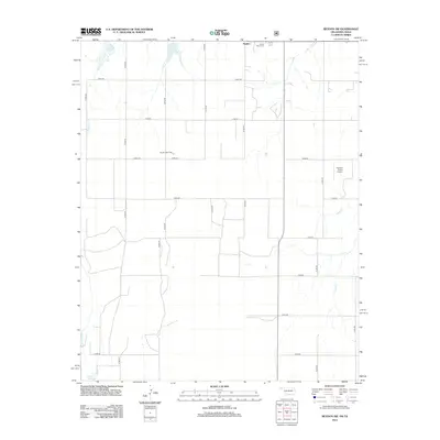
2012 Map of Reydon SW
USGS Topo · Published 2012About this map
Rankin and the surrounding rangeland of Roger Mills County are defined by a grid of rural section roads and the energy infrastructure of the High Plains. This early 21st-century landscape includes the Reydon Gas Field, which highlights the region's reliance on mineral extraction alongside traditional ranching. Local history is anchored by the White Rose Cem in the northeast and family-held landmarks like the Flying S Ranch Airport. The terrain is drained by the ephemeral branches of Rush Cr and Croton Cr, while the Davis Reservoir in the southwest provides essential water management for this arid environment. The map details a transition from the agricultural heritage of the Oklahoma-Texas border toward more modern industrial and private aviation uses.
Find a feature on this map
22 named features on this map. Tap any name to fly to it.
Don’t see what you’re looking for? This feature index may not catch every label — zoom into the map to look around manually.
Map Details
Editions of this 2012 Reydon SW Map
This is the sole edition of this map. No revisions or reprints were ever made.
Other maps of this area

1954 · Amarillo
USGS Topo · 1:250,000

1955 · Clinton
USGS Topo · 1:250,000

1957 · Clinton
USGS Topo · 1:250,000

1958 · Amarillo
USGS Topo · 1:250,000

1960 · Sweetwater
USGS Topo · 1:62,500

1961 · Reydon
USGS Topo · 1:62,500

1963 · Allison
USGS Topo · 1:24,000

1963 · Kelton
USGS Topo · 1:24,000

1967 · Hackberry Creek
USGS Topo · 1:24,000
1982 · Pampa
USGS Topo · 1:100,000