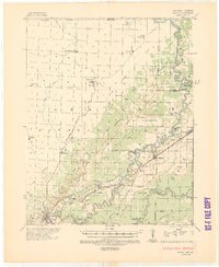
1935 Map of Reyno
USGS Topo · Published 1943About this map
Pocahontas anchors the southwest corner of this drainage study, where the Black River meets the rolling terrain of the Ozark Hills. The landscape is defined by the sharp transition at the Escarpment, which separates the high ground of the Ozarks from the low-lying alluvial plains to the east. This lower basin is a complex network of managed waterways, including Big Ditch and a series of numbered laterals like Lateral No 1 and Lateral No 8, alongside natural features such as Running Lake.
Find a feature on this map
53 named features on this map. Tap any name to fly to it.
Don’t see what you’re looking for? This feature index may not catch every label — zoom into the map to look around manually.
Map Details
Editions of this 1935 Reyno Map
3 editions found
Other maps of this area

1932 · Walnut Ridge
USGS Topo · 1:62,500

1934 · Powhatan
USGS Topo · 1:62,500

1935 · Powhatan
USGS Topo · 1:62,500

1935 · Acorn
USGS Topo · 1:62,500

1935 · Knobel
USGS Topo · 1:62,500

1935 · Reyno
USGS Topo · 1:62,500

1935 · Walnut Ridge
USGS Topo · 1:62,500

1939 · Doniphan
USGS Topo · 1:62,500

1940 · Naylor
USGS Topo · 1:62,500

1940 · Gainesville
USGS Topo · 1:62,500