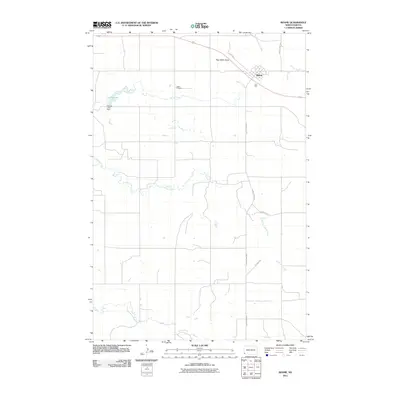
2011 Map of Rhame
USGS Topo · Published 2011About this map
The town of Rhame sits at a historic intersection of rail and road in the southwestern corner of North Dakota. This landscape is defined by its wide drainage patterns and intermittent water sources, notably the winding Coyote Creek and Spring Creek, which feeds into Spring Lake. Local topography is highlighted by Post Office Butte, a prominent landmark rising north of the main settlement. The map reveals the layout of the rural road network, from the central Railroad St to outlying paths like Oil Well Rd and Old Hwy 12, which trace the path of earlier transit corridors. Genealogists may find particular value in the presence of Tuttle Cemetery, located west of the town center near the banks of the creek. The area is also marked by local infrastructure such as the Spring Lake Dam, which manages the limited water resources in this prairie environment.
Find a feature on this map
13 named features on this map. Tap any name to fly to it.
Don’t see what you’re looking for? This feature index may not catch every label — zoom into the map to look around manually.
Map Details
Editions of this 2011 Rhame Map
This is the sole edition of this map. No revisions or reprints were ever made.
Other maps of this area

1953 · Dickinson
USGS Topo · 1:250,000

1957 · Dickinson
USGS Topo · 1:250,000

1973 · Camel Butte
USGS Topo · 1:24,000
1973 · Rhame SE
USGS Topo · 1:24,000

1973 · Griffin
USGS Topo · 1:24,000

1973 · Cedar Hills
USGS Topo · 1:24,000
1973 · Mud Buttes
USGS Topo · 1:24,000

1973 · Rhame
USGS Topo · 1:24,000

1979 · Ives
USGS Topo · 1:24,000

1981 · Bowman
USGS Topo · 1:100,000