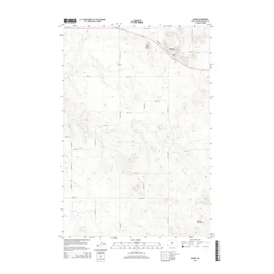
2014 Map of Rhame
USGS Topo · Published 2014About this map
Rhame sits along the northern edge of this North Dakota landscape, situated where the railway and Us-12 parallel each other through the prairie. The settlement is defined by its grid, featuring streets like Main St N and Fargo Blvd that reflect a classic plains rail-town layout. Southwest of the town center, the Tuttle Cem provides a point of genealogical interest, while the natural terrain is marked by prominent high points such as Post Office Butte and the Medicine Pole Hills to the southeast. Waterways including Spring Cr, Coyote Cr, and W Fork Deep Cr meander through the sections, often punctuated by small bodies like Spring Lake. The map reveals a highly structured environment organized by a dense network of section roads, including 81st St SW and 88th St SW, which illustrate the persistent influence of the Public Land Survey System on modern land management and habitation.
Find a feature on this map
22 named features on this map. Tap any name to fly to it.
Don’t see what you’re looking for? This feature index may not catch every label — zoom into the map to look around manually.
Map Details
Editions of this 2014 Rhame Map
This is the sole edition of this map. No revisions or reprints were ever made.
Other maps of this area

1953 · Dickinson
USGS Topo · 1:250,000

1957 · Dickinson
USGS Topo · 1:250,000

1973 · Camel Butte
USGS Topo · 1:24,000
1973 · Rhame SE
USGS Topo · 1:24,000

1973 · Griffin
USGS Topo · 1:24,000

1973 · Cedar Hills
USGS Topo · 1:24,000
1973 · Mud Buttes
USGS Topo · 1:24,000

1973 · Rhame
USGS Topo · 1:24,000

1979 · Ives
USGS Topo · 1:24,000

1981 · Bowman
USGS Topo · 1:100,000