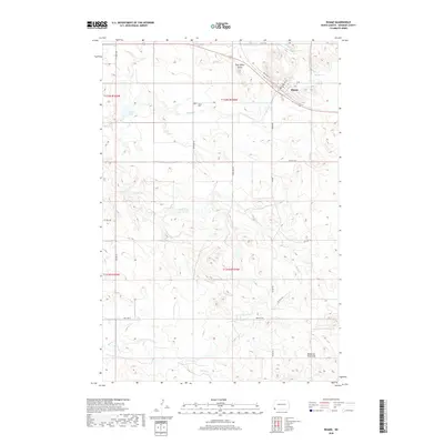
2018 Map of Rhame
USGS Topo · Published 2018About this map
The town of Rhame serves as the focal point of this southwestern North Dakota landscape, situated along a transportation corridor defined by Railroad St and Main St. The surrounding terrain in Bowman County is characterized by significant topographic rises, most notably Post Office Butte to the north and the Medicine Pole Hills to the south. These landmarks rise above a network of seasonal watercourses including Spring Cr and Coyote Cr, which drain the open prairie.
Find a feature on this map
27 named features on this map. Tap any name to fly to it.
Don’t see what you’re looking for? This feature index may not catch every label — zoom into the map to look around manually.
Map Details
Editions of this 2018 Rhame Map
This is the sole edition of this map. No revisions or reprints were ever made.
Other maps of this area

1953 · Dickinson
USGS Topo · 1:250,000

1957 · Dickinson
USGS Topo · 1:250,000

1973 · Camel Butte
USGS Topo · 1:24,000
1973 · Rhame SE
USGS Topo · 1:24,000

1973 · Griffin
USGS Topo · 1:24,000

1973 · Cedar Hills
USGS Topo · 1:24,000
1973 · Mud Buttes
USGS Topo · 1:24,000

1973 · Rhame
USGS Topo · 1:24,000

1979 · Ives
USGS Topo · 1:24,000

1981 · Bowman
USGS Topo · 1:100,000