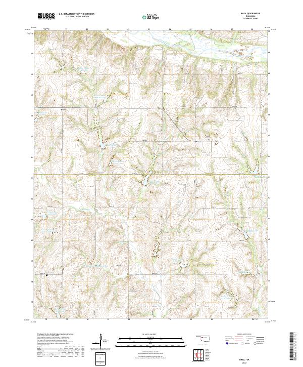
2022 Map of Rhea
USGS Topo · Published 2022About this map
The Canadian River cuts across the northern edge of this landscape, where the rural settlement of Rhea sits at a crossroads in the western plains. This area, spanning the Dewey and Custer County line, is defined by an extensive system of water management. Numerous numbered reservoirs, such as Barnitz Cr Site 40 Reservoir and Barnitz Cr Site 7 Reservoir, are distributed along the drainage of W Barnitz Cr and its tributaries, reflecting the critical importance of soil and water conservation in this region of Oklahoma. Local history is anchored by the German Cem in the southwest and Center Point Cem near the eastern boundary. The grid-like road network, consisting of routes like e0800 RD and e0840 RD, provides access to these remote family-named landmarks and agricultural sites.
Find a feature on this map
37 named features on this map. Tap any name to fly to it.
Don’t see what you’re looking for? This feature index may not catch every label — zoom into the map to look around manually.
Map Details
Editions of this 2022 Rhea Map
This is the sole edition of this map. No revisions or reprints were ever made.
Other maps of this area

1955 · Clinton
USGS Topo · 1:250,000

1957 · Clinton
USGS Topo · 1:250,000

1957 · Butler
USGS Topo · 1:62,500

1960 · Hammon
USGS Topo · 1:62,500

1961 · Leedey
USGS Topo · 1:62,500

1962 · Aledo
USGS Topo · 1:62,500

1976 · Butler NW
USGS Topo · 1:24,000

1976 · Butler NE
USGS Topo · 1:24,000
1983 · Anthon
USGS Topo · 1:24,000
1983 · Butler
USGS Topo · 1:24,000