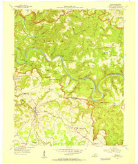
1954 Map of Rhoda
USGS Topo · Published 1955About this map
The Green River carves a deep, winding course through the karst landscape of the Mammoth Cave National Park in this 1954 survey. The map details a transition between the protected parklands and the settled agricultural communities to the south, such as Rhoda and Chalybeate. In the park interior, small islands like Crump Island and Stice Island dot the river, while the complex terrain is marked by deep hollows and named ridges like Collie Ridge. Cultural landmarks like the Maple Springs Ranger Sta and Houchins Ferry provide evidence of the park's early management and accessibility. South of the park boundary, the map reveals a network of rural life centered around local institutions, including Silent Grove Ch and Capitol Hill Sch. Small family cemeteries like Jaggers Cem and Spillman Cem are scattered throughout the region, offering significant data for genealogical research into the area's mid-century residents.
Find a feature on this map
71 named features on this map. Tap any name to fly to it.
Don’t see what you’re looking for? This feature index may not catch every label — zoom into the map to look around manually.
Map Details
Editions of this 1954 Rhoda Map
This is the sole edition of this map. No revisions or reprints were ever made.
Other maps of this area

1922 · Leitchfield
USGS Topo · 1:48,000

1922 · Brownsville
USGS Topo · 1:62,500

1922 · Mammoth Cave
USGS Topo · 1:62,500

1923 · Mammoth Cave
USGS Topo · 1:62,500

1923 · Brownsville
USGS Topo · 1:62,500

1925 · Cub Run
USGS Topo · 1:62,500

1925 · Leitchfield
USGS Topo · 1:62,500

1953 · Bee Spring
USGS Topo · 1:24,000

1954 · Evansville
USGS Topo · 1:250,000
1954 · Dickeys Mills
USGS Topo · 1:24,000