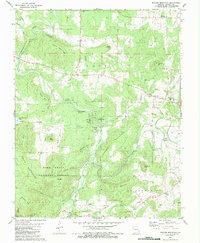
1980 Map of Rhodes Mountain
USGS Topo · Published 1983About this map
The St Francis River and its major tributary, the Little St Francis River, wind through the heart of these wooded highlands within the Mark Twain National Forest. This section of the St. Francois Mountains is notably marked by geological features like the Tiemann Shut-in and Mud Creek Shut-in, where the rivers are constricted by resistant igneous rock. The mining history of the region is evident through the presence of the Silver Mine, Einstein Mine, and the Apex Mine near the riverbanks. Local social history is anchored by the German Community Hall in the northeast and small settlements like Lance and Oak Grove. For genealogists, the map identifies numerous family-named burial grounds, including the Ashlock Cem, Wilson Cem, and Chubb Cem, which dot the landscape near small country churches like Bethel Ch and Wesley Chapel.
Find a feature on this map
73 named features on this map. Tap any name to fly to it.
Don’t see what you’re looking for? This feature index may not catch every label — zoom into the map to look around manually.
Map Details
Editions of this 1980 Rhodes Mountain Map
2 editions found
Other maps of this area

1926 · Des Arc
USGS Topo · 1:62,500

1929 · Des Arc
USGS Topo · 1:62,500

1930 · Coldwater
USGS Topo · 1:62,500

1937 · Ironton
USGS Topo · 1:48,000

1939 · Fredericktown
USGS Topo · 1:48,000

1945 · Ironton
USGS Topo · 1:62,500

1946 · Ironton
USGS Topo · 1:62,500

1947 · Fredericktown
USGS Topo · 1:62,500

1949 · Rolla
USGS Topo · 1:250,000

1949 · Coldwater
USGS Topo · 1:62,500