
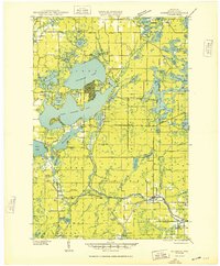
1949 Map of Rice Lake
USGS Topo · Published 1961About this map
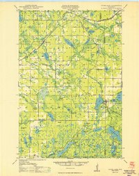
Red Cedar Lake and Long Lake dominate this post-war Wisconsin landscape, where the interconnected waters of the Northwoods define the local geography. The settlement at Rice Lake anchor the southern portion of the sheet, supported by the Chicago and Northwestern rail line and the nearby Rice Lake Municipal Airport. This mid-century survey reveals a dense network of rural infrastructure, including numerous one-room schoolhouses like Pioneer Sch and Fadness Sch, alongside community focal points such as Immanuel Ch and the Cedar Lake Cemetery. Northward, the village of Birchwood sits near the junction of several counties, overlooking the sprawling waters of Birch Lake. The map details a transition from small-town commerce to a recreation and timber-rich terrain marked by many smaller water bodies, including Little Devils Lake and Floyd Lake.
Find a feature on this map
105 named features on this map. Tap any name to fly to it.
Don’t see what you’re looking for? This feature index may not catch every label — zoom into the map to look around manually.
Map Details
Editions of this 1949 Rice Lake Map
This is the sole edition of this map. No revisions or reprints were ever made.
Other maps of this area

1944 · Couderay
USGS Topo · 1:48,000

1945 · Meteor
USGS Topo · 1:48,000
1948 · Couderay
USGS Topo · 1:48,000
1948 · Spooner
USGS Topo · 1:48,000
1948 · Stone Lake
USGS Topo · 1:48,000

1948 · Weyerhauser
USGS Topo · 1:48,000

1949 · Meteor
USGS Topo · 1:48,000
1949 · Spooner
USGS Topo · 1:48,000

1950 · Weyerhauser
USGS Topo · 1:48,000
1950 · Stone Lake
USGS Topo · 1:48,000