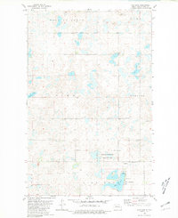
1980 Map of Rice Lake
USGS Topo · Published 1981About this map
Glacial prairie potholes and small depressions define the topography of this Ward County landscape as it appeared in the late 1970s. The southern portion of the map is dominated by Rice Lake, which serves as a recreational hub with its dedicated Public Access, Campground, and the adjacent Rice Lake Park. Significant land is also preserved for conservation within the National Waterfowl Production Area, reflecting the region's importance to migratory bird populations.
Find a feature on this map
22 named features on this map. Tap any name to fly to it.
Don’t see what you’re looking for? This feature index may not catch every label — zoom into the map to look around manually.
Map Details
Editions of this 1980 Rice Lake Map
This is the sole edition of this map. No revisions or reprints were ever made.
Other maps of this area

1928 · Minot
USGS Topo · 1:62,500

1948 · Minot NW
USGS Topo · 1:24,000

1949 · Minot NW
USGS Topo · 1:24,000

1954 · Minot
USGS Topo · 1:250,000

1954 · McClusky
USGS Topo · 1:250,000

1958 · McClusky
USGS Topo · 1:250,000

1958 · Minot
USGS Topo · 1:250,000

1980 · Minot
USGS Topo · 1:100,000

1980 · Lake Vernon
USGS Topo · 1:24,000

1980 · Rice Lake NW
USGS Topo · 1:24,000