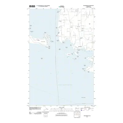
2011 Map of Richardson
USGS Topo · Published 2011About this map
San Juan Island and the southern tip of Lopez Island meet at the entrance to the Strait of Juan de Fuca, defining a landscape of rocky points and maritime navigation. The small settlement of Richardson sits along the shoreline of Jones Bay, near several small-scale water management features such as Goodrow Dam and Duroucher Dam. Coastal geography is particularly intricate here, with numerous hazardous formations like Whale Rocks, Secar Rock, and Mummy Rocks dotting the waters near Long Island and Charles Island. On the western shore, the prominent Mount Finlayson rises above Cattle Point, where the Cattle Point Light marks the transition between the Inner Passage and the open strait. Inland, the community is served by the Lopez Island Airport and the Lopez Union Cemetery, reflecting the enduring local infrastructure of these island communities.
Find a feature on this map
96 named features on this map. Tap any name to fly to it.
Don’t see what you’re looking for? This feature index may not catch every label — zoom into the map to look around manually.
Map Details
Editions of this 2011 Richardson Map
This is the sole edition of this map. No revisions or reprints were ever made.
Other maps of this area

1943 · Richardson
USGS Topo · 1:62,500

1943 · Orcas Island
USGS Topo · 1:62,500

1954 · Friday Harbor
USGS Topo · 1:24,000

1954 · False Bay
USGS Topo · 1:24,000

1957 · Richardson
USGS Topo · 1:62,500

1957 · Orcas Island
USGS Topo · 1:62,500

1957 · Victoria
USGS Topo · 1:250,000
1973 · Lopez Pass
USGS Topo · 1:24,000

1973 · Shaw Island
USGS Topo · 1:24,000
1973 · Blakely Island
USGS Topo · 1:24,000