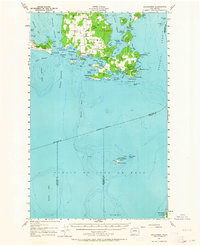
1957 Map of Richardson
USGS Topo · Published 1964About this map
The southern shoreline of Lopez Island and the expansive waters of the Strait of Juan de Fuca define this coastal landscape at the end of the 1950s. The settlement at Richardson serves as a primary point of interest on the southwestern coast, while the interior reveals a mix of local infrastructure such as the Lopez Sch and a Cemetery. This survey, based on culture revised in 1957, captures the marine-oriented character of the San Juan Islands, illustrating a network of sheltered bays like Mackaye Harbor and Aleck Bay alongside elevated terrain features like Lopez Hill and Chadwick Hill. To the south, isolated landmarks like the Smith Island National Wildlife Refuge and Minor Island stand as sentinels within the shipping channels. The map provides a look at the interplay of terrestrial landmarks and underwater features, including Salmon Bank and McArthur Bank, which were vital for navigation in this era.
Find a feature on this map
68 named features on this map. Tap any name to fly to it.
Don’t see what you’re looking for? This feature index may not catch every label — zoom into the map to look around manually.
Map Details
Editions of this 1957 Richardson Map
2 editions found

Other maps of this area

1938 · Dungeness
USGS Topo · 1:62,500

1939 · Port Townsend
USGS Topo · 1:62,500

1939 · Dungeness
USGS Topo · 1:62,500

1939 · Coupeville
USGS Topo · 1:62,500

1943 · Richardson
USGS Topo · 1:62,500

1943 · Orcas Island
USGS Topo · 1:62,500

1943 · Deception Pass
USGS Topo · 1:62,500

1943 · Anacortes
USGS Topo · 1:62,500

1951 · Deception Pass
USGS Topo · 1:62,500

1951 · Anacortes
USGS Topo · 1:62,500