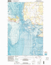
1998 Map of Richardson
USGS Topo · Published 2002About this map
Richardson stands as a primary coastal landing on the southern tip of Lopez Island, situated where the Middle Channel meets the Strait of Juan de Fuca. This late-twentieth-century survey illustrates a landscape defined by maritime navigation and conservation, featuring the San Juan Islands Nat Wildlife Refuge across numerous offshore rocks and islands like Long Island and Charles Island. On San Juan Island to the west, the San Juan Island National Historical Park preserves the area surrounding Mt Finlayson, while the bathymetry reveals the underwater topography of the Salmon Bank. Interior development is concentrated along corridors like Fisherman Bay Road, leading toward the Lopez Island Airport and a local School, reflecting the island's transition into a community supported by both local industry and its position within the San Juan archipelago.
Find a feature on this map
53 named features on this map. Tap any name to fly to it.
Don’t see what you’re looking for? This feature index may not catch every label — zoom into the map to look around manually.
Map Details
Editions of this 1998 Richardson Map
This is the sole edition of this map. No revisions or reprints were ever made.
Other maps of this area

1943 · Richardson
USGS Topo · 1:62,500

1943 · Orcas Island
USGS Topo · 1:62,500

1954 · Friday Harbor
USGS Topo · 1:24,000

1954 · False Bay
USGS Topo · 1:24,000

1957 · Richardson
USGS Topo · 1:62,500

1957 · Orcas Island
USGS Topo · 1:62,500

1957 · Victoria
USGS Topo · 1:250,000
1973 · Lopez Pass
USGS Topo · 1:24,000

1973 · Shaw Island
USGS Topo · 1:24,000
1973 · Blakely Island
USGS Topo · 1:24,000