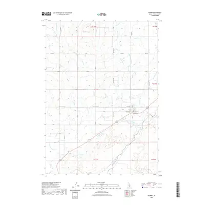
2020 Map of Richfield
USGS Topo · Published 2020About this map
Richfield sits as the central hub of an intricate irrigation network in this Idaho landscape. The town plan is oriented along the Little Wood River, which meanders across the southern portion of the quadrangle. North of the settlement, the terrain is dominated by an extensive system of water management, including the West Main Canal, East Main Canal, and dozens of numbered laterals like Lateral 1096 and Lateral 1150. These canals reflect the agricultural engineering required to sustain the high desert. To the northwest, the prominent Johnson Butte rises above the surrounding plains, providing a significant geological landmark. The map also traces older natural water features like the Jim Burns Slough and Cottonwood Slough, which run alongside the modern man-made channels such as the Dietrich Main Canal.
Find a feature on this map
70 named features on this map. Tap any name to fly to it.
Don’t see what you’re looking for? This feature index may not catch every label — zoom into the map to look around manually.
Map Details
Editions of this 2020 Richfield Map
This is the sole edition of this map. No revisions or reprints were ever made.
Other maps of this area

1955 · Twin Falls
USGS Topo · 1:250,000

1955 · Hailey
USGS Topo · 1:250,000

1958 · Twin Falls
USGS Topo · 1:250,000

1959 · Hailey
USGS Topo · 1:250,000

1962 · Hailey
USGS Topo · 1:250,000

1971 · Owinza
USGS Topo · 1:24,000

1971 · Dietrich
USGS Topo · 1:24,000

1971 · Dietrich Butte
USGS Topo · 1:24,000
1979 · Richfield
USGS Topo · 1:24,000

1979 · Shoshone Ice Cave
USGS Topo · 1:24,000