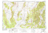
1953 Map of Richfield
USGS Topo · Published 1974About this map
Sevier Lake and the arid expanse of the Sevier Desert dominate the northern reaches of this mid-century survey, while the eastern edge is defined by the high peaks of the Tushar Mountains and the Pavant Range. The agricultural and mining corridor along the Sevier River and U.S. 89 connects established settlements like Richfield and Elsinore to the volcanic landscapes of Tabernacle Hill. Industrial signatures of the era are evident in the Beaver Power Plant No 1 and scattered mining operations including the Cactus Mine and Golden Reef Mine.
Find a feature on this map
101 named features on this map. Tap any name to fly to it.
Don’t see what you’re looking for? This feature index may not catch every label — zoom into the map to look around manually.
Map Details
Editions of this 1953 Richfield Map
3 editions found

Other maps of this area

1885 · Manti
USGS Topo · 1:250,000

1885 · St. George
USGS Topo · 1:250,000

1885 · Beaver
USGS Topo · 1:250,000

1885 · Sevier Desert
USGS Topo · 1:250,000

1885 · Fish Lake
USGS Topo · 1:250,000

1885 · Pioche
USGS Topo · 1:250,000

1886 · Kanab
USGS Topo · 1:250,000

1886 · Escalante
USGS Topo · 1:250,000

1886 · Pioche
USGS Topo · 1:250,000

1891 · St. George
USGS Topo · 1:250,000