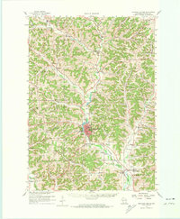
1960 Map of Richland Center
USGS Topo · Published 1974About this map
The Pine River corridor serves as the primary artery for this portion of Richland County, anchored by the seat at Richland Center. In the early 1960s, the Chicago Milwaukee St Paul and Pacific railroad still traversed the valley, passing near industrial and civic landmarks like the County Fairground and the Sewage Disposal plant. The landscape is defined by its deep drainage networks, with numerous "hollows" such as Jacquish Hollow and Hell Hollow carved between prominent landforms like Hulst Ridge and Chicken Ridge.
Find a feature on this map
104 named features on this map. Tap any name to fly to it.
Don’t see what you’re looking for? This feature index may not catch every label — zoom into the map to look around manually.
Map Details
Editions of this 1960 Richland Center Map
3 editions found
Other maps of this area

1905 · Richland Center
USGS Topo · 1:125,000

1926 · La Farge
USGS Topo · 1:62,500

1927 · Hillsboro
USGS Topo · 1:62,500

1933 · Boaz
USGS Topo · 1:62,500

1933 · Boscobel
USGS Topo · 1:62,500

1956 · Reedsburg
USGS Topo · 1:62,500

1958 · La Crosse
USGS Topo · 1:250,000

1960 · Richland Center
USGS Topo · 1:62,500

1960 · Plain
USGS Topo · 1:62,500

1960 · Muscoda
USGS Topo · 1:62,500