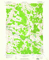
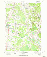
1958 Map of Richland
USGS Topo · Published 1960About this map
The Salmon River anchors this mid-century portrait of Oswego County, winding its way through the townships of Richland and Albion. The rail-centered village of Richland serves as a junction for the New York Central railroad, while the larger settlement of Pulaski sits to the west near the confluence of Spring Brook and the river. Numerous family-named cemeteries such as Stevens Cem and McClelland Cem are scattered throughout the landscape, providing essential touchpoints for genealogical research.
Find a feature on this map
55 named features on this map. Tap any name to fly to it.
Don’t see what you’re looking for? This feature index may not catch every label — zoom into the map to look around manually.
Map Details
Editions of this 1958 Richland Map
3 editions found

Other maps of this area

1895 · Pulaski
USGS Topo · 1:62,500

1903 · Orwell
USGS Topo · 1:62,500

1905 · Orwell
USGS Topo · 1:62,500

1905 · Mexico
USGS Topo · 1:62,500

1906 · Kasoag
USGS Topo · 1:62,500

1942 · Sandy Creek
USGS Topo · 1:24,000
1943 · Pulaski
USGS Topo · 1:31,680

1943 · Boylston
USGS Topo · 1:31,680

1943 · Richland
USGS Topo · 1:31,680

1943 · Mexico
USGS Topo · 1:31,680