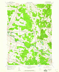
1958 Map of Richland
USGS Topo · Published 1960This historical map portrays the area of Richland in 1958, primarily covering Oswego County. Featuring a scale of 1:24000, this map provides a highly detailed snapshot of the terrain, roads, buildings, counties, and historical landmarks in the Richland region at the time. Published in 1960, it is one of 3 known editions of this map due to revisions or reprints.
Find a feature on this map
55 named features on this map. Tap any name to fly to it.
Don’t see what you’re looking for? This feature index may not catch every label — zoom into the map to look around manually.
Map Details
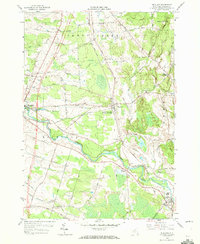
Editions of this 1958 Richland Map
3 editions found
Historical Maps of Altmar Through Time
40 maps found

1903 Orwell
Oswego County, NY

1905 Mexico
Oswego County, NY

1905 Orwell
Oswego County, NY

1906 Kasoag
Oswego County, NY

1942 Redfield
Oswego County, NY

1943 Boylston
Oswego County, NY

1943 Dugway
Oswego County, NY

1943 Hannibal
Oswego County, NY

1943 Mallory
Oswego County, NY

1943 Mexico
Oswego County, NY

1943 New Haven
Oswego County, NY

1943 Orwell
Oswego County, NY

1943 Oswego East
Oswego County, NY

1943 Oswego West
Oswego County, NY

1943 Panther Lake
Oswego County, NY

1943 Pennellville
Oswego County, NY

1943 Redfield
Oswego County, NY

1943 Richland
Oswego County, NY

1943 Texas
Oswego County, NY

1943 West Of Texas
Oswego County, NY

1943 Williamstown
Oswego County, NY

1943 Worth Center
Oswego County, NY

1954 Hannibal
Oswego County, NY

1954 Oswego East
Oswego County, NY

1954 Oswego West
Oswego County, NY

1955 Texas
Oswego County, NY

1955 West Of Texas
Oswego County, NY

1956 Mexico
Oswego County, NY

1956 New Haven
Oswego County, NY

1956 Pennellville
Oswego County, NY

1957 Dugway
Oswego County, NY

1957 Mallory
Oswego County, NY

1958 Richland
Oswego County, NY

1959 Boylston Center
Oswego County, NY

1959 Orwell
Oswego County, NY

1959 Panther Lake
Oswego County, NY

1960 Redfield
Oswego County, NY

1960 Williamstown
Oswego County, NY

1960 Worth Center
Oswego County, NY

1978 Hannibal
Oswego County, NY