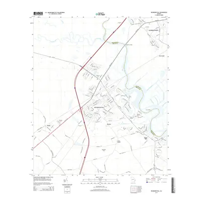
2014 Map of Richmond Hill
USGS Topo · Published 2014About this map
The Ogeechee River and its confluence with the Canoochee River define the intricate waterways south of Savannah, where the boundary between Chatham County and Bryan County follows the river's winding path. This coastal landscape is marked by a complex system of historical drainage and navigation channels, including Peachtree Canal, Valambrosia Canal, and Elbow Canal, which surround Ford Island. The settlement pattern centers on Richmond Hill, with smaller community nodes at Georgetown, Burroughs, and Brisbon. For genealogists, the map is particularly detailed regarding local burial grounds, showing Bethlehem Cem, Cherry Hill Cem, and the uniquely named Burnt Church Cem near the southern edge. The Kings Ferry Bridge provides a vital crossing point on the Coastal Highway, linking the riverbanks near Port Royal and the marshes of Ogeechee Neck.
Find a feature on this map
147 named features on this map. Tap any name to fly to it.
Don’t see what you’re looking for? This feature index may not catch every label — zoom into the map to look around manually.
Map Details
Editions of this 2014 Richmond Hill Map
This is the sole edition of this map. No revisions or reprints were ever made.
Other maps of this area

1920 · Meldrim
USGS Topo · 1:62,500

1920 · Limerick
USGS Topo · 1:62,500

1942 · Meldrim
USGS Topo · 1:62,500

1942 · Savannah
USGS Topo · 1:62,500

1944 · Limerick
USGS Topo · 1:62,500

1944 · Ossabaw Island
USGS Topo · 1:62,500

1945 · Ossabaw Island
USGS Topo · 1:62,500

1946 · Brunswick
USGS Topo · 1:250,000

1947 · Savannah
USGS Topo · 1:250,000

1948 · Brunswick
USGS Topo · 1:250,000