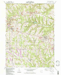
1994 Map of Richmond
USGS Topo · Published 1998About this map
The rugged hill country of Jefferson County, Ohio, is defined here by the deep incision of Town Fork and its tributaries, revealing a landscape heavily shaped by both conservation and extraction. Jefferson Lake State Park preserves the waters of Jefferson Lake at the center of the sheet, while surrounding ridges like Middle Ridge and Timothy Ridge are scarred by extensive strip mines. These industrial excavations contrast sharply with the quiet, established settlements of Richmond and East Springfield. For genealogists, the map is particularly rich in burial sites and religious landmarks, including the St John Vianney Seminary, Mt Zion Ch, and various family-named plots such as Montgomery Cem. The transition from old crossroads like Old Annapolis to the active rural communities of the 1990s illustrates the persistent settlement patterns of the Old Seven Ranges region.
Find a feature on this map
50 named features on this map. Tap any name to fly to it.
Don’t see what you’re looking for? This feature index may not catch every label — zoom into the map to look around manually.
Map Details
Editions of this 1994 Richmond Map
This is the sole edition of this map. No revisions or reprints were ever made.
Other maps of this area

1901 · Cadiz
USGS Topo · 1:62,500

1903 · Cadiz
USGS Topo · 1:62,500

1904 · Wellsville
USGS Topo · 1:62,500

1904 · Steubenville
USGS Topo · 1:62,500

1905 · Salineville
USGS Topo · 1:62,500

1935 · Steubenville
USGS Topo · 1:62,500

1937 · Wellsville
USGS Topo · 1:62,500

1942 · Steubenville
USGS Topo · 1:62,500

1944 · Wellsville
USGS Topo · 1:62,500

1951 · Canton
USGS Topo · 1:250,000