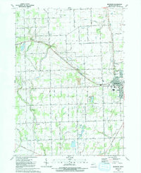
1991 Map of Richmond
USGS Topo · Published 1991About this map
Richmond serves as the primary hub in this corner of Macomb and St. Clair Counties, showing the city's established grid and the tracks of the GT railroad. The surrounding landscape is defined by an intricate network of agricultural drainage, with named watercourses like Coon Creek and the Harrison Drain dissecting the fertile fields. To the west, the Armada Corp Bdy and settlements like St Josephs Shrine provide a window into the region's spiritual and social geography in the early 1990s. Local history is deeply etched into the land through numerous burial grounds, including the Richards Cem and Bates Cem, which stand near the vanished Willow Grove (Site). Further south, the St Joseph Novitiate and the residential pocket at Lake Chalet reflect the varied land use between the rural expanses and the growing town centers, all connected by a dense lattice of numbered section roads such as 32 Mile Road and Plank Road.
Find a feature on this map
79 named features on this map. Tap any name to fly to it.
Don’t see what you’re looking for? This feature index may not catch every label — zoom into the map to look around manually.
Map Details
Editions of this 1991 Richmond Map
This is the sole edition of this map. No revisions or reprints were ever made.
Other maps of this area

1912 · Mt Clemens
USGS Topo · 1:62,500

1914 · Armada
USGS Topo · 1:62,500

1914 · Algonac
USGS Topo · 1:62,500

1928 · Armada
USGS Topo · 1:62,500

1928 · Hicky
USGS Topo · 1:62,500

1929 · Mt Clemens
USGS Topo · 1:62,500

1936 · New Haven
USGS Topo · 1:31,680

1936 · Waldenburg
USGS Topo · 1:31,680

1936 · New Baltimore
USGS Topo · 1:31,680

1939 · New Baltimore
USGS Topo · 1:24,000