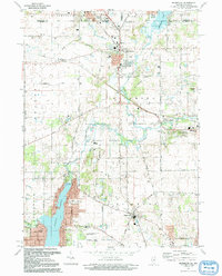
1992 Map of Richmond
USGS Topo · Published 1992About this map
The North Branch of the Nippersink Creek winds through this Illinois-Wisconsin borderland, anchoring a landscape defined by its glacial hydrology and agricultural roots. The village of Richmond serves as a central hub, where the Chicago and North Western corridor meets local landmarks like First Baptist Ch and the Richmond Sch. To the south, the expansion of Glacial County Park and Harrison-Benwell County Park preserves the natural terrain near Ringwood, while the developed shoreline of Wonder Lake and Wondermere shows the mid-century growth of residential recreation. Local history is deeply etched into the geography through several family and parish burial sites, including Washington Cem and St Josephs Cem, alongside infrastructure such as the Galt Airport and the remnants of an Old Railroad Grade branching toward Genoa City.
Find a feature on this map
66 named features on this map. Tap any name to fly to it.
Don’t see what you’re looking for? This feature index may not catch every label — zoom into the map to look around manually.
Map Details
Editions of this 1992 Richmond Map
This is the sole edition of this map. No revisions or reprints were ever made.
Other maps of this area

1893 · Silver Lake
USGS Topo · 1:62,500

1893 · Geneva
USGS Topo · 1:62,500

1904 · Lake Geneva
USGS Topo · 1:62,500

1906 · Silver Lake
USGS Topo · 1:62,500

1906 · Lake Geneva
USGS Topo · 1:62,500

1920 · Grays Lake
USGS Topo · 1:62,500

1923 · Grays Lake
USGS Topo · 1:62,500

1926 · Mc Henry
USGS Topo · 1:62,500

1944 · McHenry
USGS Topo · 1:62,500

1954 · Rockford
USGS Topo · 1:250,000