
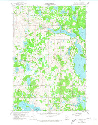
1959 Map of Richwood
USGS Topo · Published 1960About this map
The White Earth Indian Reservation Boundary cuts across the northern landscape of this Becker County survey, framing a region defined by its dense network of glacial lakes and wetlands. The settlement of Richwood sits at the headwaters where the Buffalo River exits Buffalo Lake, a site of early local industry as evidenced by nearby Gravel Pits.
Find a feature on this map
37 named features on this map. Tap any name to fly to it.
Don’t see what you’re looking for? This feature index may not catch every label — zoom into the map to look around manually.
Map Details
Editions of this 1959 Richwood Map
2 editions found
Other maps of this area

1953 · Brainerd
USGS Topo · 1:250,000

1954 · Bemidji
USGS Topo · 1:250,000

1957 · Brainerd
USGS Topo · 1:250,000

1957 · Bemidji
USGS Topo · 1:250,000

1958 · Bemidji
USGS Topo · 1:250,000

1958 · Brainerd
USGS Topo · 1:250,000

1959 · Flat Lake
USGS Topo · 1:24,000

1959 · Rochert
USGS Topo · 1:24,000
1959 · Callaway
USGS Topo · 1:24,000
1959 · Audubon
USGS Topo · 1:24,000