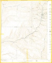
1899 Map of Rico
USGS Topo · Published 1905About this map
Rico serves as the focal point for this late nineteenth-century surveying effort, nestled in a high-elevation landscape where the Rio Grande Southern railroad follows the winding path of the Dolores River. The map captures a moment of frontier transition, showing the infrastructure required to support the local mining and ranching economy. Individual homesteads and ranching operations like Rogers Ranch and Robinsons Ranch are situated along the river valleys and creek beds, while the surrounding terrain is dominated by prominent summits including Expectation Mtn., Sockrider Peak, and Calico Peak.
Find a feature on this map
55 named features on this map. Tap any name to fly to it.
Don’t see what you’re looking for? This feature index may not catch every label — zoom into the map to look around manually.
Map Details
Editions of this 1899 Rico Map
5 editions found
Other maps of this area

1895 · La Plata
USGS Topo · 1:62,500

1897 · La Plata
USGS Topo · 1:62,500

1897 · Rico
USGS Topo · 1:62,500

1897 · Telluride
USGS Topo · 1:62,500

1898 · Durango
USGS Topo · 1:62,500

1898 · Engineer Mountain
USGS Topo · 1:62,500

1898 · Rico
USGS Topo · 1:62,500

1899 · La Plata
USGS Topo · 1:62,500

1899 · Rico
USGS Topo · 1:62,500

1900 · Engineer Mountain
USGS Topo · 1:62,500