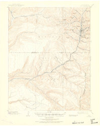
1899 Map of Rico
USGS Topo · Published 1951About this map
Rico serves as the industrial and social anchor of this 1890s survey, situated along the upper reaches of the Dolores River. The landscape is dominated by the silver-mining era's infrastructure, notably the R.G.S. R.R. (Rio Grande Southern Railroad) which snakes along the river valley to connect high-altitude outposts. Outside the concentrated mining activity near Dolores Mtn. and Aztec Gulch, the map reveals a network of pioneer homesteads and agricultural holdings, including Roger's Ranch, Love's Ranch, and Snyder's Ranch. These family-named landmarks, often situated at the confluence of mountain streams like Stoner Creek and Bear Creek, provide a rare look at the distribution of early settlers within the San Juan National Forest boundary before modern development altered the valley floor. Significant peaks like Sockrider Peak and Anchor Mtn. define the high country, while a lonely Quarry near Taylor Creek hints at the localized extraction industries of the day.
Find a feature on this map
55 named features on this map. Tap any name to fly to it.
Don’t see what you’re looking for? This feature index may not catch every label — zoom into the map to look around manually.
Map Details
Editions of this 1899 Rico Map
5 editions found
Other maps of this area

1895 · La Plata
USGS Topo · 1:62,500

1897 · La Plata
USGS Topo · 1:62,500

1897 · Rico
USGS Topo · 1:62,500

1897 · Telluride
USGS Topo · 1:62,500

1898 · Durango
USGS Topo · 1:62,500

1898 · Engineer Mountain
USGS Topo · 1:62,500

1898 · Rico
USGS Topo · 1:62,500

1899 · La Plata
USGS Topo · 1:62,500

1899 · Rico
USGS Topo · 1:62,500

1900 · Engineer Mountain
USGS Topo · 1:62,500