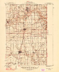
1947 Map of Ridge Farm
USGS Topo · Published 1947About this map
Georgetown and the surrounding prairie towns of eastern Illinois sit at a transport nexus in the mid-1940s, where heavy rail lines and rural schools define the landscape. The Chicago and Eastern Illinois and New York Central railroads intersect at Chrisman, anchoring a network that connects smaller settlements like Ridge Farm, Olivet, and Indianola. This survey captures a dense rural society characterized by a high frequency of one-room schoolhouses and country churches, such as Washington Sch and the Friends Ch at Vermilion Grove. The terrain transitions from the open flats of Ross and Prairie townships to the winding drainage of the Little Vermilion River and Brouilletts Creek. The presence of small family and community burial grounds, including the Sandusky Cem and Martha Smith Cem, provides a detailed record of the families who settled this border region near the Indiana state line.
Find a feature on this map
94 named features on this map. Tap any name to fly to it.
Don’t see what you’re looking for? This feature index may not catch every label — zoom into the map to look around manually.
Map Details
Editions of this 1947 Ridge Farm Map
3 editions found
Other maps of this area

1899 · Danville
USGS Topo · 1:62,500

1900 · Danville
USGS Topo · 1:62,500

1931 · Fithian
USGS Topo · 1:48,000

1943 · Fithian
USGS Topo · 1:62,500

1946 · Kansas
USGS Topo · 1:62,500

1947 · Ridge Farm
USGS Topo · 1:62,500

1947 · Paris
USGS Topo · 1:62,500

1949 · Kansas
USGS Topo · 1:62,500

1949 · Paris
USGS Topo · 1:62,500

1949 · Danville SW
USGS Topo · 1:24,000