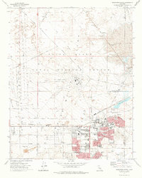
1973 Map of Ridgecrest North
USGS Topo · Published 1976About this map
The NAF China Lake (Armitage Field) dominates this high desert landscape, highlighting the mid-1970s growth of Ridgecrest as a vital military and research hub. The town's expansion is evident through a dense network of residential streets such as West Drummond Ave and Anita St, supported by community institutions like Burroughs High Sch, Las Flores Sch, and Richmond Sch. The infrastructure of the era is marked by the U S Government Railroad and a prominent Aqueduct, which underscore the logistical demands of the Naval Weapons Center. To the east, the dry basins of Mirror Lake and Satellite Lake contrast with developed features like the China Lake Golf Club and Kern County Regional Park. Local landmarks, including the Drive-in Theater and several observation towers in Little Lake Valley, provide a detailed view of the region's mid-century transition into a specialized defense community.
Find a feature on this map
73 named features on this map. Tap any name to fly to it.
Don’t see what you’re looking for? This feature index may not catch every label — zoom into the map to look around manually.
Map Details
Editions of this 1973 Ridgecrest North Map
This is the sole edition of this map. No revisions or reprints were ever made.
Other maps of this area

1915 · Searles Lake
USGS Topo · 1:250,000

1943 · Inyokern
USGS Topo · 1:62,500

1947 · Trona
USGS Topo · 1:250,000

1948 · Trona
USGS Topo · 1:250,000

1953 · Mountain Springs Canyon
USGS Topo · 1:62,500

1953 · Ridgecrest
USGS Topo · 1:62,500

1953 · Trona
USGS Topo · 1:250,000

1954 · Little Lake
USGS Topo · 1:62,500

1957 · Trona
USGS Topo · 1:250,000

1960 · Trona
USGS Topo · 1:250,000