1954 Map of Little Lake
USGS Topo · Published 1955About this map
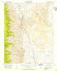
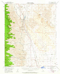
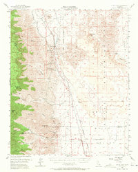
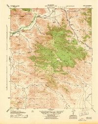
Rose Valley serves as a critical corridor in the mid-1950s, where the Southern Pacific railroad and the Los Angeles Aqueduct parallel each other through the arid landscape of eastern California. The settlement of Little Lake stands at a geological transition point, surrounded by massive lava flows and volcanic landmarks like Volcano Peak and Red Hill. To the west, the steep Sierra Nevada foothills are carved by numerous canyons, including Sacatar and Ninemile, while to the east, the Coso Basin reveals archaeological significance through Indian Petroglyphs. The map documents a heavily managed landscape, featuring industrial and military footprints such as a Cinder Pit, various Prospect sites, and the expansive Naval Ordnance Test Station boundary. Small track-side locales like Linnie and Brown illustrate the sparse but vital rail-based settlement pattern of the era.
Find a feature on this map
45 named features on this map. Tap any name to fly to it.
Don’t see what you’re looking for? This feature index may not catch every label — zoom into the map to look around manually.
Map Details
Editions of this 1954 Little Lake Map
3 editions found
Other maps of this area

1905 · Olancha
USGS Topo · 1:125,000

1906 · Kernville
USGS Topo · 1:125,000

1907 · Olancha
USGS Topo · 1:125,000

1908 · Kernville
USGS Topo · 1:125,000

1908 · Ballarat
USGS Topo · 1:250,000

1913 · Ballarat
USGS Topo · 1:250,000

1915 · Searles Lake
USGS Topo · 1:250,000
1943 · Inyokern
USGS Topo · 1:62,500
1943 · Onyx
USGS Topo · 1:62,500

1947 · Trona
USGS Topo · 1:250,000