
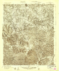
1931 Map of Ridgetop
USGS Topo · Published 1957About this map
The Louisville and Nashville RR serves as a central artery through this landscape, threading between Greenbrier and Ridgetop as it follows the high ground. This early 1930s survey captures the rural infrastructure of Robertson and Davidson counties, defined by a dense network of country schools like Pinson Sch and Chestnut Grove Sch, alongside community anchors such as St Michaels Ch and Lights Chapel.
Find a feature on this map
102 named features on this map. Tap any name to fly to it.
Don’t see what you’re looking for? This feature index may not catch every label — zoom into the map to look around manually.
Map Details
Editions of this 1931 Ridgetop Map
2 editions found
Other maps of this area

1903 · Nashville
USGS Topo · 1:125,000

1930 · White Bluff
USGS Topo · 1:62,500

1932 · Hermitage
USGS Topo · 1:62,500

1932 · Nashville
USGS Topo · 1:62,500

1933 · White Bluff
USGS Topo · 1:62,500

1935 · Ridgetop
USGS Topo · 1:62,500

1942 · Gallatin
USGS Topo · 1:100,000

1942 · Lebanon
USGS Topo · 1:100,000

1952 · Goodlettsville
USGS Topo · 1:24,000

1952 · Springfield North
USGS Topo · 1:24,000