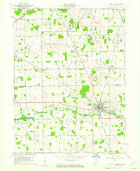
1960 Map of Ridgeville
USGS Topo · Published 1961About this map
The Mississinewa River cuts through the heart of this Indiana landscape, following the historic Indian Treaty Boundary that segments the townships of Franklin and Ward. The settlement of Ridgeville serves as a local hub at the junction of the Pennsylvania railroad and several regional waterways. This 1960s-era record reveals a highly organized rural infrastructure, dotted with numerous family and community burial grounds such as Flesher Cem, Wentz Cem, and the Odd Fellows Cem. Local centers of faith and education, including Pleasant Vale Ch and the Township Sch near New Mt Pleasant, anchor the agricultural community. The map also documents the industrial presence of several Gas Wells and Quarries, illustrating the intersection of natural resources and established settlement patterns along the Jay and Randolph County line.
Find a feature on this map
47 named features on this map. Tap any name to fly to it.
Don’t see what you’re looking for? This feature index may not catch every label — zoom into the map to look around manually.
Map Details
Editions of this 1960 Ridgeville Map
3 editions found

Other maps of this area

1915 · Fort Recovery
USGS Topo · 1:48,000

1916 · Winchester
USGS Topo · 1:48,000

1918 · Winchester
USGS Topo · 1:62,500

1918 · Fort Recovery
USGS Topo · 1:62,500

1943 · Winchester
USGS Topo · 1:62,500

1952 · Maxville
USGS Topo · 1:24,000

1952 · Farmland
USGS Topo · 1:24,000

1953 · Muncie
USGS Topo · 1:250,000

1956 · Muncie
USGS Topo · 1:250,000

1960 · Pennville
USGS Topo · 1:24,000