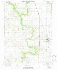
1963 Map of Ridgway
USGS Topo · Published 1986About this map
The North Fork Saline River meanders through the heart of this Southern Illinois landscape, defining the topography near the Saline and Gallatin County line. The village of Ridgway serves as the primary population center, established along the Baltimore and Ohio railroad line. This 1963 field survey reveals a rural economy shaped by both agriculture and extraction, evidenced by the sprawling Omaha Oil and Gas Field in the northwest. Local history is deeply etched into the terrain through a network of country churches and burial grounds, such as Zion Ch, Union Chapel Cem, and St Josephs Cem. To the south, the land rises toward the prominence of Gold Hill, while smaller settlements like Elba and landmarks like the Purcell Cem mark the intersections of early local roads and waterways like Cane Creek and Crawford Creek.
Find a feature on this map
23 named features on this map. Tap any name to fly to it.
Don’t see what you’re looking for? This feature index may not catch every label — zoom into the map to look around manually.
Map Details
Editions of this 1963 Ridgway Map
2 editions found
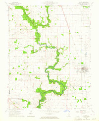
Other maps of this area

1905 · Eldorado
USGS Topo · 1:62,500

1905 · New Haven
USGS Topo · 1:62,500

1906 · New Haven
USGS Topo · 1:62,500

1906 · Eldorado
USGS Topo · 1:62,500

1916 · Shawneetown
USGS Topo · 1:62,500

1916 · Equality
USGS Topo · 1:62,500

1949 · Paducah
USGS Topo · 1:250,000

1949 · New Haven
USGS Topo · 1:62,500

1950 · Paducah
USGS Topo · 1:250,000

1954 · Paducah
USGS Topo · 1:250,000