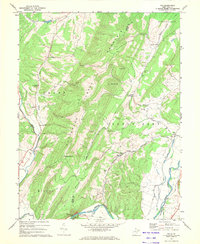
1967 Map of Rig
USGS Topo · Published 1972About this map
Patterson Creek Mountain dominates the center of this terrain, separating the winding course of Patterson Creek from the eastern valley of the South Fork Potomac River. The landscape is defined by its distinct ridges, including Huckleberry Ridge and Turkey Mtn, which frame small upland communities like Kessel and Rig. This 1960s era topography shows a network of local roads and religious centers such as Mt Carmel Ch and Oak Grove Ch, which served the scattered residents of Milroy and South Fork districts.
Find a feature on this map
40 named features on this map. Tap any name to fly to it.
Don’t see what you’re looking for? This feature index may not catch every label — zoom into the map to look around manually.
Map Details
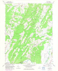
Editions of this 1967 Rig Map
2 editions found
Other maps of this area

1891 · Romney
USGS Topo · 1:125,000

1892 · Franklin
USGS Topo · 1:125,000

1892 · Woodstock
USGS Topo · 1:125,000

1895 · Piedmont
USGS Topo · 1:125,000

1896 · Franklin
USGS Topo · 1:125,000

1920 · Petersburg
USGS Topo · 1:48,000

1920 · Moorefield
USGS Topo · 1:62,500

1921 · Orkney Springs
USGS Topo · 1:48,000

1921 · Petersburg
USGS Topo · 1:48,000

1921 · Greenland Gap
USGS Topo · 1:62,500