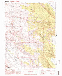
1985 Map of Rill Creek
USGS Topo · Published 1986About this map
Castle Valley and the dramatic drop of the Porcupine Rim dominate the topography of this mid-1980s provisional survey. The landscape is defined by its deep drainage networks, including Jackass Canyon and Negro Bill Canyon, which cut through the high sandstone plateaus. In the southwest, the Spanish Valley floor supports more modern local infrastructure, such as a Golf Course and Rodeo Ground, alongside a quiet Cem. The map documents a complex web of 4WD tracks and trails navigating the transition from the mesa tops at Johnsons Up On Top down to the creek beds. Water sources are critical in this arid environment, marked here by Rill Creek and various Springs that feed into the larger North Fork Mill Creek system.
Find a feature on this map
22 named features on this map. Tap any name to fly to it.
Don’t see what you’re looking for? This feature index may not catch every label — zoom into the map to look around manually.
Map Details
Editions of this 1985 Rill Creek Map
2 editions found
Other maps of this area

1885 · La Sal
USGS Topo · 1:250,000

1954 · Mt Peale 2 NW
USGS Topo · 1:24,000

1954 · Mt. Waas 3 NE
USGS Topo · 1:24,000

1954 · Mt. Waas 3 SE
USGS Topo · 1:24,000

1954 · Carlisle 1 NE
USGS Topo · 1:24,000

1954 · Mt Peale 2 NE
USGS Topo · 1:24,000

1954 · Mt. Waas 3 NW
USGS Topo · 1:24,000

1954 · Mt. Waas 3 SW
USGS Topo · 1:24,000

1954 · La Sal Junction
USGS Topo · 1:62,500

1954 · Castle Valley
USGS Topo · 1:62,500