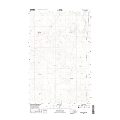
2017 Map of Rimrock Ranch
USGS Topo · Published 2017About this map
Rimrock Ranch stands as a focal point in this portion of Glacier County, situated in an area defined by the drainage patterns of Powell Coulee. The landscape is organized by the Public Land Survey System, with the intersections of t36n r10w, t36n r9w, t35n r10w, and t35n r9w marking the cadastral framework of the High Plains. Transportation in this ranching country is dictated by a handful of established routes, most notably Meriwether Rd, which runs north-south along the eastern edge of the quadrangle. Other secondary roads like Horsethief Rd and Thorn Rd provide access to the interior, where the topography transitions from flat plateaus into the seasonal watercourses of the coulees.
Find a feature on this map
9 named features on this map. Tap any name to fly to it.
Don’t see what you’re looking for? This feature index may not catch every label — zoom into the map to look around manually.
Map Details
Editions of this 2017 Rimrock Ranch Map
This is the sole edition of this map. No revisions or reprints were ever made.
Other maps of this area

1911 · Blackfoot
USGS Topo · 1:125,000

1960 · Cut Bank
USGS Topo · 1:250,000

1963 · Cut Bank
USGS Topo · 1:250,000

1964 · Cut Bank
USGS Topo · 1:250,000

1968 · Buffalo Lake
USGS Topo · 1:24,000

1968 · Rimrock Butte
USGS Topo · 1:24,000
1968 · Fort Piegan
USGS Topo · 1:24,000
1968 · Del Bonita
USGS Topo · 1:24,000
1968 · Sharp Lake
USGS Topo · 1:24,000

1968 · Landslide Butte
USGS Topo · 1:24,000