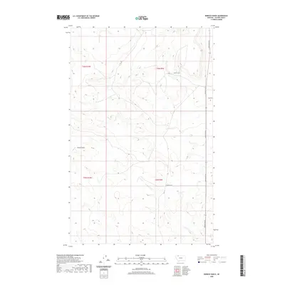
2020 Map of Rimrock Ranch
USGS Topo · Published 2020About this map
Rimrock Ranch stands as the primary landmark in this section of Glacier County, north of the Blackfeet Reservation. The landscape is defined by the drainage patterns of Powell Coulee, where seasonal watercourses have carved paths through the high plains. The transport network is sparse but functional, centered on north-south transit along Meriwether Rd, which connects remote ranching operations to the wider region. Intersecting routes like Thorn Rd and Horsethief Rd trace the property boundaries of T36N and T35N, reflecting the geometric grid of the Public Land Survey System. This terrain illustrates the vast, open-range character of Northern Montana, where life is dictated by the availability of water and the accessibility of isolated homesteads via gravel roads.
Find a feature on this map
9 named features on this map. Tap any name to fly to it.
Don’t see what you’re looking for? This feature index may not catch every label — zoom into the map to look around manually.
Map Details
Editions of this 2020 Rimrock Ranch Map
This is the sole edition of this map. No revisions or reprints were ever made.
Other maps of this area

1911 · Blackfoot
USGS Topo · 1:125,000

1960 · Cut Bank
USGS Topo · 1:250,000

1963 · Cut Bank
USGS Topo · 1:250,000

1964 · Cut Bank
USGS Topo · 1:250,000

1968 · Buffalo Lake
USGS Topo · 1:24,000

1968 · Rimrock Butte
USGS Topo · 1:24,000
1968 · Fort Piegan
USGS Topo · 1:24,000
1968 · Del Bonita
USGS Topo · 1:24,000
1968 · Sharp Lake
USGS Topo · 1:24,000

1968 · Landslide Butte
USGS Topo · 1:24,000