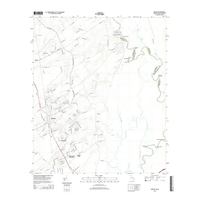
2014 Map of Rincon
USGS Topo · Published 2014About this map
The town of Rincon serves as a central hub in this survey, where the expanding residential grids meet the dense network of wetlands and creeks that drain toward the Savannah River. The map reveals a landscape defined by its historic cemeteries, including Rincon Cem, Gnann Cem, and Rahn Cem, which offer significant value for genealogical research in Effingham County. To the south, residential developments such as Willowpeg, Silverwood Plantation, and Goshen Villa show the late-century suburban growth pattern pushing into former agricultural or timber lands. The eastern edge of the quadrangle is dominated by the intricate hydrology of the river basin, featuring numerous named points like Big Kiffer Point and Glovers Point, along with backwater features like Coleman Lake and Fox Lake. This map captures the transition from the concentrated settlement at Birds to the more modern corridors defined by Ga-21.
Find a feature on this map
144 named features on this map. Tap any name to fly to it.
Don’t see what you’re looking for? This feature index may not catch every label — zoom into the map to look around manually.
Map Details
Editions of this 2014 Rincon Map
This is the sole edition of this map. No revisions or reprints were ever made.
Other maps of this area

1919 · Egypt
USGS Topo · 1:62,500

1920 · Hardeeville
USGS Topo · 1:62,500

1920 · Meldrim
USGS Topo · 1:62,500

1939 · Egypt
USGS Topo · 1:62,500

1942 · Meldrim
USGS Topo · 1:62,500

1942 · Savannah
USGS Topo · 1:62,500

1943 · Hardeeville
USGS Topo · 1:62,500

1943 · Egypt
USGS Topo · 1:62,500

1947 · Savannah
USGS Topo · 1:250,000

1948 · Savannah
USGS Topo · 1:250,000