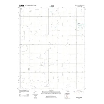
2010 Map of Ringwood SW
USGS Topo · Published 2010About this map
Hoyle Creek meanders through this portion of Major County, defining the drainage patterns of an area characterized by a rigorous section-line road grid. The landscape is marked by small-scale water management projects, including the Sugar Creek Site 30 Dam and the Oknoname 093001 Reservoir in the northeast. This 2010 survey highlights a deeply rooted rural community, where long-standing landmarks like Glenwood Cemetery, Concord Cemetery, and Ames Cemetery are preserved alongside active sites like Decker Field. The convergence of Elm Creek and the surrounding tributary network suggests a landscape shaped by both natural watercourses and the agricultural needs of the Oklahoma plains, with the road network providing the primary structure for the region's development.
Find a feature on this map
25 named features on this map. Tap any name to fly to it.
Don’t see what you’re looking for? This feature index may not catch every label — zoom into the map to look around manually.
Map Details
Editions of this 2010 Ringwood SW Map
This is the sole edition of this map. No revisions or reprints were ever made.
Other maps of this area

1893 · Ames
USGS Topo · 1:62,500

1955 · Woodward
USGS Topo · 1:250,000

1956 · Ames
USGS Topo · 1:62,500

1956 · Ringwood
USGS Topo · 1:62,500

1958 · Woodward
USGS Topo · 1:250,000

1969 · Fairview NE
USGS Topo · 1:24,000

1969 · Fairview SE
USGS Topo · 1:24,000
1972 · Isabella
USGS Topo · 1:24,000
1982 · Ringwood
USGS Topo · 1:24,000
1982 · Barr
USGS Topo · 1:24,000