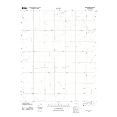
2012 Map of Ringwood SW
USGS Topo · Published 2012About this map
Major County land in the early 2010s is defined by a rigid section-line road grid and the winding paths of seasonal watercourses. The landscape is primarily agricultural, punctuated by several historic burial grounds that serve as landmarks for local genealogy, including Era Cem in the north and Concord Cem further east. The drainage of Hoyle Cr meanders south through the center of the quadrangle, crossing numerous east-west routes such as e0470 RD and e0500 RD. Near the northern boundary, the Decker Field Airport stands as a notable point of infrastructure, while Glenwood Cem and Ames Cem provide further reference points for tracing family histories across this rural Oklahoma terrain.
Find a feature on this map
25 named features on this map. Tap any name to fly to it.
Don’t see what you’re looking for? This feature index may not catch every label — zoom into the map to look around manually.
Map Details
Editions of this 2012 Ringwood SW Map
This is the sole edition of this map. No revisions or reprints were ever made.
Other maps of this area

1893 · Ames
USGS Topo · 1:62,500

1955 · Woodward
USGS Topo · 1:250,000

1956 · Ames
USGS Topo · 1:62,500

1956 · Ringwood
USGS Topo · 1:62,500

1958 · Woodward
USGS Topo · 1:250,000

1969 · Fairview NE
USGS Topo · 1:24,000

1969 · Fairview SE
USGS Topo · 1:24,000
1972 · Isabella
USGS Topo · 1:24,000
1982 · Ringwood
USGS Topo · 1:24,000
1982 · Barr
USGS Topo · 1:24,000