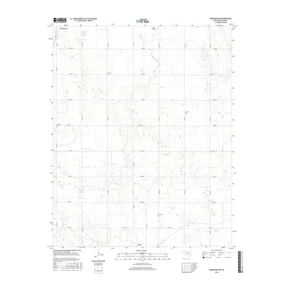
2016 Map of Ringwood SW
USGS Topo · Published 2016About this map
Ringwood and Ames anchor the northern and southern edges of this Major County landscape, where the agricultural grid is defined by a rigorous network of section line roads like N2700 Rd and E0490 Rd. The terrain is subtly carved by the winding course of Hoyle Cr, which moves south toward the town of Ames, while Sugar Creek Site 30 Reservoir provides a significant water management feature in the southwest quadrant.
Find a feature on this map
27 named features on this map. Tap any name to fly to it.
Don’t see what you’re looking for? This feature index may not catch every label — zoom into the map to look around manually.
Map Details
Editions of this 2016 Ringwood SW Map
This is the sole edition of this map. No revisions or reprints were ever made.
Other maps of this area

1893 · Ames
USGS Topo · 1:62,500

1955 · Woodward
USGS Topo · 1:250,000

1956 · Ames
USGS Topo · 1:62,500

1956 · Ringwood
USGS Topo · 1:62,500

1958 · Woodward
USGS Topo · 1:250,000

1969 · Fairview NE
USGS Topo · 1:24,000

1969 · Fairview SE
USGS Topo · 1:24,000
1972 · Isabella
USGS Topo · 1:24,000
1982 · Ringwood
USGS Topo · 1:24,000
1982 · Barr
USGS Topo · 1:24,000