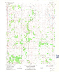
1982 Map of Ringwood SW
USGS Topo · Published 1983About this map
Oil and gas fields dominate the central landscape of this Major County region, where industrial development overlays a deeply rooted rural infrastructure. The rail-and-river geography is defined by the Burlington Northern line and Hoyle Creek, which provide the orientation for the settlements of Ames and Ringwood. For genealogists and local historians, the sheet is particularly valuable for its preservation of smaller community anchors, including several well-spaced burial grounds such as Erie Cem, Glenwood Cem, and Concord Cem. The presence of the Parker Ch and a Lookout Tower suggests a landscape shaped by both community faith and early resource management. This survey captures a moment when the traditional farming and township structure of western Oklahoma coexisted with a maturing energy extraction economy.
Find a feature on this map
17 named features on this map. Tap any name to fly to it.
Don’t see what you’re looking for? This feature index may not catch every label — zoom into the map to look around manually.
Map Details
Editions of this 1982 Ringwood SW Map
This is the sole edition of this map. No revisions or reprints were ever made.
Other maps of this area

1893 · Ames
USGS Topo · 1:62,500

1955 · Woodward
USGS Topo · 1:250,000

1956 · Ames
USGS Topo · 1:62,500

1956 · Ringwood
USGS Topo · 1:62,500

1958 · Woodward
USGS Topo · 1:250,000

1969 · Fairview NE
USGS Topo · 1:24,000

1969 · Fairview SE
USGS Topo · 1:24,000
1972 · Isabella
USGS Topo · 1:24,000
1982 · Ringwood
USGS Topo · 1:24,000
1982 · Barr
USGS Topo · 1:24,000