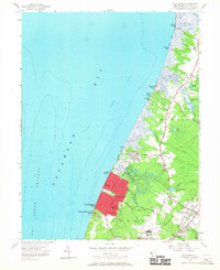
1956 Map of Rio Grande
USGS Topo · Published 1967About this map
Delaware Bay defines the western edge of this coastal landscape, where a series of small landings and beach communities such as Reeds Beach, Kimbles Beach, and Norburys Landing sit along the shoreline. The interior is characterized by the low-lying hydrology of Middle and Lower townships, featuring extensive wetlands and named water bodies like Kay Pond and Fishing Creek. The development of Villas and Bowman Manor represents mid-century residential expansion near the bay, supported by infrastructure like the Cape May County Airport and the Pennsylvania-Reading Seashore Lines. Local history is anchored by landmarks such as the Fishing Creek Sch and the County Mosquito Commission Lookout Tower, which reflects the specific environmental management needs of this marshy Atlantic peninsula. Transportation corridors like Indian Trail Road and Shinpike Road link established settlements like Rio Grande to the recreational and maritime activities along the coast.
Find a feature on this map
51 named features on this map. Tap any name to fly to it.
Don’t see what you’re looking for? This feature index may not catch every label — zoom into the map to look around manually.
Map Details
Editions of this 1956 Rio Grande Map
4 editions found
Other maps of this area

1888 · Cape May
USGS Topo · 1:62,500

1888 · Dennisville
USGS Topo · 1:62,500

1890 · Maurice Cove
USGS Topo · 1:62,500

1891 · Maurice Cove
USGS Topo · 1:62,500

1893 · Cape May
USGS Topo · 1:62,500

1894 · Dennisville
USGS Topo · 1:62,500

1898 · Cape May
USGS Topo · 1:62,500

1899 · Vineland
USGS Topo · 1:125,000

1918 · Cape Henlopen
USGS Topo · 1:62,500

1918 · Cape May
USGS Topo · 1:62,500
Featured Places
- Lower Township, NJ
- Middle Township, NJ
- Villas, Lower Township
- Kimseytown, Lower Township
- King Crab Landing, Middle Township