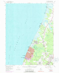
1956 Map of Rio Grande
USGS Topo · Published 1990About this map
Delaware Bay defines the western edge of this coastal landscape, where the Fishing Creek Shoal meets a string of bayside settlements. The shoreline transitions from the marshy environments of Reeds Beach and Kimbles Beach in the north to the more densely gridded residential pockets of Villas and Del Haven. Inland, the geography is shaped by the transition from tidal creeks like Green Creek and Fishing Creek to the upland woods and clearings around Dias Creek.
Find a feature on this map
54 named features on this map. Tap any name to fly to it.
Don’t see what you’re looking for? This feature index may not catch every label — zoom into the map to look around manually.
Map Details
Editions of this 1956 Rio Grande Map
4 editions found
Other maps of this area

1888 · Cape May
USGS Topo · 1:62,500

1888 · Dennisville
USGS Topo · 1:62,500

1890 · Maurice Cove
USGS Topo · 1:62,500

1891 · Maurice Cove
USGS Topo · 1:62,500

1893 · Cape May
USGS Topo · 1:62,500

1894 · Dennisville
USGS Topo · 1:62,500

1898 · Cape May
USGS Topo · 1:62,500

1899 · Vineland
USGS Topo · 1:125,000

1918 · Cape Henlopen
USGS Topo · 1:62,500

1918 · Cape May
USGS Topo · 1:62,500
Featured Places
- Lower Township, NJ
- Middle Township, NJ
- Villas, Lower Township
- Kimseytown, Lower Township
- King Crab Landing, Middle Township