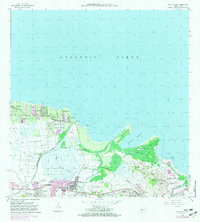
1963 Map of Rio Grande
USGS Topo · Published 1982About this map
The coastal plains of northeastern Puerto Rico meet the Atlantic Ocean in this topographical study, highlighting a landscape defined by sugar cultivation and rising urban footprints. Centered on the town of Rio Grande, the map reveals a network of watercourses including the Rio Herrera and Rio Espiritu Santo that irrigate the low-lying Cienaga Baja. The presence of the Ferrocarril rail line and numerous agricultural canals suggests the historical dominance of the sugar industry, even as newer developments like the Pista de Aterrizaje and Campo de Golf signal a shift toward tourism and modern infrastructure. From the barrios of Mediania Baja to the elevated peaks of Cerro Bravo, the map documents established local communities and institutions, including the Escuela Luis Calderon and Escuela Juan Gonzalez, providing a clear view of the region's social and economic geography during the early 1960s and its 1982 revisions.
Find a feature on this map
61 named features on this map. Tap any name to fly to it.
Don’t see what you’re looking for? This feature index may not catch every label — zoom into the map to look around manually.
Map Details
Editions of this 1963 Rio Grande Map
4 editions found
Other maps of this area

1940 · Carolina
USGS Topo · 1:30,000

1941 · Rio Grande
USGS Topo · 1:30,000

1941 · Carolina
USGS Topo · 1:30,000

1945 · El Yunque
USGS Topo · 1:30,000

1946 · El Yunque
USGS Topo · 1:30,000

1946 · Gurabo
USGS Topo · 1:30,000

1946 · Fajardo
USGS Topo · 1:30,000

1947 · Carolina
USGS Topo · 1:30,000

1947 · El Yunque NE
USGS Topo · 1:10,000

1947 · Gurabo NE
USGS Topo · 1:10,000